The Heart of Roman Jerusalem
The destruction of Jerusalem by the Romans did not occur, contrary to popular opinion, with the suppression of the Great Revolt in 70 AD. Although Jerusalem suffered a severe blow and the Temple was destroyed, Jewish life in the city and in the Land of Israel continued even after that. About 60 years later, the Bar Kokhba Rebellion broke out, the last great struggle of the in Israel against Roman rule, during the reign of Emperor Hadrian between 132-136 AD. The Bar Kokhba rebellion was severely suppressed, and the country lay devastated in absolute ruin. Hundreds of towns and villages were destroyed and hundreds of thousands of Jewish residents were killed or exiled. Jerusalem was almost completely wiped out this time, and on top of its ruins the Romans built a Roman city called Aelia Capitolina.
הערים הרומיות, כמו גם מחנות הצבא הרומי, נבנו בתבנית קבועה של שתי וערב. הרחוב הראשי שחצה את העיר מצפון לדרום נקרא קארדו, והרחוב הניצב שחצה אותו ממזרח למערב נקרא דקומנוס. שני הרחובות חילקו את העיר לארבעה רבעים – ומכאן הכינוי "רובע" לאזור מסוים בעיר עד היום. הקארדו היה רחובה המסחרי הראשי של העיר הרומית – נסללה בו דרך רחבה ונבנו לאורכו חנויות ובתי מסחר. הכיכר הגדולה שנוצרה בצומת הדרכים שבין הקארדו לדקומנוס, בה שכן הפורום הרומי, הייתה מקום המפגש וההתכנסות העיקרי של תושבי העיר ושימשה לניהול ענייני הציבור.
The Romans built a cardo in Aelia Capitolina too, which extended from the Nablus Gate to the area of today's Church of the Holy Sepulchre. A few hundred years later, during the reign of Emperor Justinianus, the Byzantines extended the cardo to the Zion Gate area.
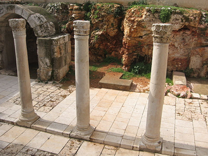
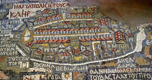
After the Six Day War, archaeological excavations were conducted in the old city and the remains of the Byzantine cardo were uncovered in the heart of the Jewish quarter. Part of the street was left open and contains remains of columns and shops, while another part was rebuilt and is used today for residential homes and commerce - just as it was 1500 years ago. In the Madaba Map, the well-known mosaic map from the 6th or 7th century AD that was discovered in the church of St. Gaugorius in the town of Madaba in Jordan, the main Aardo and Decumenus streets of Jerusalem at that time can be clearly seen. A painting of the Madaba Map can be found on the Cardo today, as well as a large wall painting illustrating how it might have looked during the Byzantine period.
(Anecdote authored by: עמיר)
(Number of views: 51)